Chincoteague & Assateague |
| home > chincoteague & Assateague islands |
 |
|
| Have you ever been on an island? | |
| Chincoteague Island | |
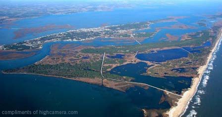
An island is land with water all around it. An island can be huge like the continent of Australia, or tiny, like Chincoteague and Assateague Islands. Chincoteague Island has a town of about 4,000 people, except on Pony Penning Day, when many thousands of people, including children who’ve read the story of Misty of Chincoteague, come to see the ponies swim from Assateague, the island closer to the ocean, to Chincoteague, the island closer to the mainland.
View this cool video below: |
|
Chincoteague has a National Wildlife Refuge. If you go to Chincoteague Island, you can become a Junior Refuge Manager. This barrier island, along with nearby islands and lagoons, is important for migrating birds. It's a World Biosphere Reserve of the United Nations because of its great ecological value. |
|
| Can you find three endangered species that live on the island? What kinds of birds could you see there? Hint: there are over 100 kinds. Some really special birds are two nesting bald eagles who fly around Chincoteague. Maybe they will have hatched some offspring by the time you read this! | |
| Islands like Chincoteague sometimes have harsh weather because they are near the ocean and are quite flat. In the story of Stormy, Misty’s Foal, Misty comes indoors to give birth to her foal. Can you imagine being near a storm like this? | |
| Assateague Island | |
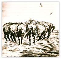
| Assateague Island, where the ponies live year round, is wilder than Chincoteague. Assateague is composed of a narrow band of sandy land with marshes, beaches, maritime forests and coastal bays. Assateague changes constantly with the ocean and wind, and is now protected as a National Seashore. People can go camping there and see the wild ponies and other wildlife, including the foxes, birds, dolphins, deer, squirrels, and horseshoe crabs, which are very ancient creatures who leave big black shells you can find. You can become a WebRanger by playing games online. If you go to Assateague, you can reach the island in a small boat, or drive over on the bridge. There is no town on Assateague Island now. | |
You will know you are on Assateague Island when you see a red, striped lighthouse. You can ride a bike along the pony trail, then climb up inside the lighthouse and see the views in every direction. Do you see the big lens on the light? That helps it shine far out to sea by focusing the light in a long beam. On some lighthouses, the light turns. Do you see the frames around the windows? As the light passes these window frames, there is a pause in the beam shining. The speed of these breaks in the beams tells sailors on ships which lighthouse the light is coming from so they can navigate safely along dangerous coasts, even in the stormy dark times. On Assateague Island, you could see some of the150 ponies running wild on the Maryland end of the island (owned by the Park Service), and another 150 ponies in pens on the Virginia end (owned by the Chincoteague Volunteer Fire Department). The ponies are kept behind fences so they don't trample the dunes or eat the plants that native species depend on. |
|
| You can make a project of finding out about these islands--they are really interesting. Here are some things you can find out by using the links on this page: |
|
How long and wide are the islands of Chincoteague and Assateague? You can make a table and fill it in with comparisons, or look at GoogleEarth and your home to compare sizes. How high is each island above sea level, and how high do you live above sea level? What is the weather like on those islands and where you live? What other factors can you compare to understand weather and climate on the islands with where you live? Rainfall, wind and temperature (highs and lows) are the easy ones. What else affects weather? How does the weather affect your life and life on the islands where the ponies live? What are the physical features of the land where you live (before buildings and roads were built)? Did you think of slope, soil drainage, borders, depth of water, parent material for the soil? You can find these using Google, which is really amazing. You have a billion-page reference source at your fingertips. Using Google you can find details about "Sinepuxent," the bay on one end of Assateague Island: the soil is so poorly drained that it's permanently submersed under two feet of water; the soil "parent" is "mixed dredge soil materials." The bedrock is 80 feet deep (so if you wanted to build a bridge, it would have to go really deep down into the sludge). The animals are tubeworms, clams, scallops, juvenile blue crabs and finfish. The plants are rooted algae, eelgrass and widgetgrass. Does widgetgrass sound like a plant in a Dr. Seuss book? Does sinepuxent sound like the slimiest place you ever heard of? If you find new facts like this about Assateague and Chincoteague that are really interesting, let us know! What borders are near each island and near your house? Assateague Island has one side on Sinepuxent Bay. Who decided on the place names around these islands and the place names where you live? That might be hard to find out--can you do it? Why is Assateague called a "border island"? How can you get to this island? Well, the horses that first came to Assateague Island had to swim there or be taken by boat, since there were no bridges 400 years ago. How did people first arrive where you live, and how long ago was that? |
|
According to the National Wildlife Refuge, the legend of the ponies coming on a Spanish Galleon might not be true. Here's another theory about how ponies really got to Assateague: The "Chincoteague Ponies" are descendants of colonial horses brought to Assateague Island in the l7th century by Eastern Shore planters when crop damage caused by free roaming animals led colonial legislatures to enact laws requiring fencing and taxes on livestock. The modern-day descendants of those domestic horses are wild and have adapted to their environment. |
|
How did people first arrive where you live? How can you find out? What is it like to live on an island? On some islands, people get their supplies by boat, but Chincoteague Island has a bridge, both to the mainland and to Assateague Island,[;] so people can drive there now. In the Misty book you will learn some things about living in the little town of Chincoteague, Virginia. About 1,200 families, 4,000 people, lived there in the year 2000. How many people live in your town or city? Have you visited small towns where you live? What influences the size of a town or city? |
|
| Some islands on the coast of a continent, like Assateague where Misty was born, are long and thin. | |
| Can you see Assateague on the old map in the Misty book? Do you think it protects the mainland and Chincoteague? Can you find Virginia and Maryland on a United States map? If your family downloads Google Earth on your computer, you can zoom in on these states using satellite photos, and see the islands close up. What do you notice? A smooth or jagged coastline? Why do you suppose the land formed like that? | |
|
Storms wash the salty water over the island, so even the plants are salty. Imagine being a wild pony on the wind-blown island of Assateague. |
You can see gorgeous photographs of Assateague Island by a National Geographic photographer, Medford Taylor, in his book, Saltwater Cowboys. There is also a movie with this title. Another good book is, Assateague: Island of Wild Ponies. |
|
|
The Assateague Island National Park reaches across both Maryland and Virginia. You can plan a trip to the park, and learn all about the birds, horses, trails, camp sites and programs for kids. People can adopt a wild Assateague pony. The pony stays on the island, so they don’t have to feed it! The National Park has a newsletter called "Horsin' Around," that tells how the wild ponies are doing. |
| Chincoteague is a town on the inner island where you can stay and do many things. You can see the location on GoogleMaps. See how Assateague is very long and thin, and extends up to Maryland, while Chincoteague is in the state of Virginia. GoogleMaps shows photos of the islands, including the beautiful striped red lighthouse on Assateague. Google also has a video showing lifeguards rescuing two people caught in the undertow off Assateague, so be careful if you go swimming. The water can look calm, then the force of the water flowing out to sea can pull you out. Swim at an angle to the shore if this ever happens to you. There are lots of tourist resources online about Chincoteague Island. | |
You can plan a pretend trip if you can't actually go there this year. Print photos of where you'd stay, where you'd stand for the pony swim, what pony you would bid on, the artist whose gallery you would visit, the photographers whose work you like most, the place you'd camp to see the pony you adopted, the beautiful flowers you would find, the animals you could see--you tell us ideas about your fantastic, pretend trip! You can use Microsoft PowerPoint or Apple Keynote to make a slide show about your pretend trip. |
|
| Each year there is still a Pony Penning Day and auction of ponies at Chincoteague, VA. It happens in July and draws over 50,000 visitors from all over the world. So if you get to go, expect crowds, and hot, muggy weather. Wouldn't it be exciting to see the ponies swim across the channel once again, and see them parade down the street to the pony pens? And to go to a real pony auction? I hope you can go! | |

